Geolocate

Carcas topographic map

Click on the map to display elevation.

About this map

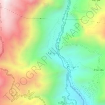
Name: Carcas topographic map, elevation, terrain.

Location: Carcas, Chiquián, Province of Bolognesi, Ancash, Peru (-10.13705 -77.18437 -10.09705 -77.14437)

Average elevation: 3,533 m

Minimum elevation: 2,999 m

Maximum elevation: 4,281 m

Gear up for your next adventure:

🎒Hiking Backpack - Lightweight and ergonomic backpacks for day hikes or multi-day treks
🧊Insulated Water Bottle - Keeps drinks cold in summer and prevents freezing in winter
👖Convertible Hiking Pants - Zip-off legs to adapt to changing weather conditions
Family Camping Tent - Spacious tent suitable for family camping trips
🎒Backpack Rain Cover - External shield to keep your entire pack dry

As an Amazon Associate, this site earns from qualifying purchases at no extra cost to you.