Geolocate

Colquepata topographic map

Click on the map to display elevation.

About this map

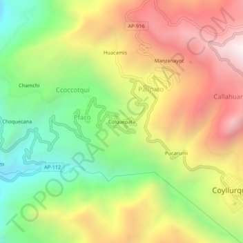
Name: Colquepata topographic map, elevation, terrain.

Location: Colquepata, Pfaco, Coyllurqui, Cotabambas, Apurímac, Perú (-13.84617 -72.47050 -13.80617 -72.43050)

Average elevation: 3,062 m

Minimum elevation: 2,342 m

Maximum elevation: 3,854 m

Gear up for your next adventure:

🪑Ultralight Camping Stool - Compact seating for rest stops during long hikes
🥘Camping Cookware Set - Compact nesting pots and pans for trail cooking
🎒Hiking Daypack - Lightweight and durable backpacks for day trips and excursions
🧥Waterproof Jacket - Lightweight rain jackets for hiking and outdoor activities
👟Trail Running Shoes - Agile footwear for fast-paced topographic exploration

As an Amazon Associate, this site earns from qualifying purchases at no extra cost to you.