Geolocate

Wangen topographic map

Click on the map to display elevation.

About this map
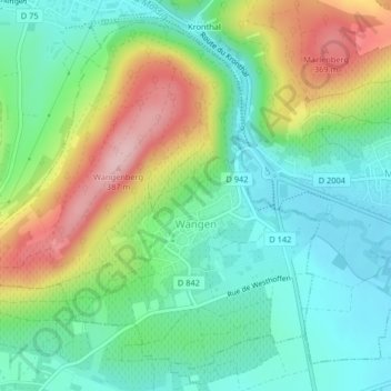
Name: Wangen topographic map, elevation, terrain.

Location: Wangen, Molsheim, Bas-Rhin, Grand Est, Metropolitan France, 67520, France (48.60824 7.44225 48.63216 7.48016)

Average elevation: 249 m

Minimum elevation: 180 m

Maximum elevation: 380 m

Other topographic maps

Click on a map to view its topography, its elevation and its terrain.
Strasbourg

France > Grand Est > Bas-Rhin > Strasbourg

Average elevation: 154 m

Ath

France > Grand Est > Bas-Rhin > Diemeringen

Average elevation: 255 m

Taubensee

France > Grand Est > Bas-Rhin > Niederbronn-les-Bains

Average elevation: 396 m

Le Haut des Monts

France > Grand Est > Bas-Rhin > Belmont

Average elevation: 849 m

Le Climont

France > Grand Est > Bas-Rhin > Urbeis

Average elevation: 621 m

Altenstadt

France > Grand Est > Bas-Rhin > Wissembourg

Average elevation: 172 m

Gear up for your next adventure:

🧴Sunscreen SPF - Broad-spectrum sunscreen for outdoor activities
🧰Multitool Knife - Compact and versatile tool for outdoor use
💡Solar Camping Lamp - Eco-friendly lighting for campsites
💧Collapsible Water Bottle - Space-saving water bottle for outdoor activities
🧢Hiking Sun Hat - Wide-brimmed protection for exposed mountain ridges

As an Amazon Associate, this site earns from qualifying purchases at no extra cost to you.