
Make a donation
Gear up for your next adventure:
As an Amazon Associate, this site earns from qualifying purchases at no extra cost to you.
Stadthafen Rostock topographic map
Click on the map to display elevation.
Make a donation
Gear up for your next adventure:
As an Amazon Associate, this site earns from qualifying purchases at no extra cost to you.
About this map
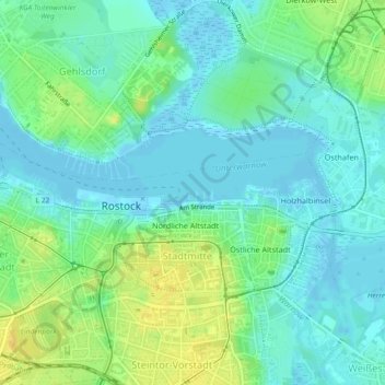
Name: Stadthafen Rostock topographic map, elevation, terrain.
Average elevation: 9 m
Minimum elevation: -4 m
Maximum elevation: 25 m
Make a donation
Gear up for your next adventure:
As an Amazon Associate, this site earns from qualifying purchases at no extra cost to you.
Other topographic maps
Click on a map to view its topography, its elevation and its terrain.
Warnemünde
Deutschland > Mecklenburg-Vorpommern > Rostock
In Warnemünde sind viele Musiker und Gruppen zu Hause, die kulturelle Höhepunkte mitgestalten, wie der Shantychor De Klaashahns, die Folkgruppe De Plattfööt, TonArt, Irish Coffee und Heide Mundo.
Average elevation: 0 m
Make a donation
Gear up for your next adventure:
As an Amazon Associate, this site earns from qualifying purchases at no extra cost to you.
Make a donation
Gear up for your next adventure:
As an Amazon Associate, this site earns from qualifying purchases at no extra cost to you.
Warnemünde
Deutschland > Mecklenburg-Vorpommern > Rostock
In Warnemünde sind viele Musiker und Gruppen zu Hause, die kulturelle Höhepunkte mitgestalten, wie der Shantychor De Klaashahns, die Folkgruppe De Plattfööt, TonArt, Irish Coffee und Heide Mundo.
Average elevation: 0 m
Make a donation
Gear up for your next adventure:
As an Amazon Associate, this site earns from qualifying purchases at no extra cost to you.