Geolocate

Weiliu topographic map

Click on the map to display elevation.

About this map

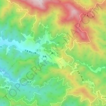
Name: Weiliu topographic map, elevation, terrain.

Location: Weiliu, Bagui, Tianlin County, Baise, Guangxi, China (24.15490 106.02200 24.19490 106.06200)

Average elevation: 669 m

Minimum elevation: 408 m

Maximum elevation: 1,035 m

Gear up for your next adventure:

🔦UV Flashlight - Detect minerals or specific insects in the dark
🥾Hiking Leggings - Comfortable leggings for outdoor activities
🧣Merino Neck Gaiter - Protects against wind, sun, and cold at high altitudes
🏃Hydration Running Vest - Carry water and maps close to your body for speed
🧦Thermal Socks - Warm socks for winter hiking or camping

As an Amazon Associate, this site earns from qualifying purchases at no extra cost to you.