
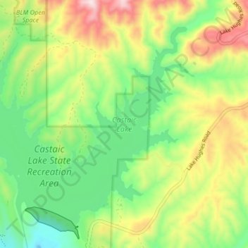
Castaic Lake topographic map
Click on the map to display elevation.
About this map
Name: Castaic Lake topographic map, elevation, terrain.
Average elevation: 537 m
Minimum elevation: 349 m
Maximum elevation: 828 m
Other topographic maps
Click on a map to view its topography, its elevation and its terrain.
San Gabriel River
United States > California > Los Angeles County > Pico Rivera
Average elevation: 89 m
Calabasas Highlands
United States > California > Los Angeles County > Calabasas
Average elevation: 404 m
Mount Wilson Observatory
United States > California > Los Angeles County > Mount Wilson
Average elevation: 1,421 m
Santa Ynez Reservoir
United States > California > Los Angeles County > Los Angeles
Average elevation: 307 m
Topanga Oaks
United States > California > Los Angeles County > Topanga > Topanga Oaks
Average elevation: 371 m
Santa Clarita
United States > California > Los Angeles County > Santa Clarita
Average elevation: 525 m
Lake Elizabeth
United States > California > Los Angeles County
The lake, at 984 m (3,228 ft) in elevation, is within the Angeles National Forest. It is a natural perennial lake, but may dry up entirely during drought years. It is south of the western Antelope Valley.
Average elevation: 1,065 m
Mount Lukens
United States > California > Los Angeles County > Los Angeles
It is in the Sunland-Tujunga community within the northeast corner of the city of Los Angeles, above the Crescenta Valley. The summit, at 5,075 feet (1,547 m) in elevation, is the highest point within the city limits. The summit's elevation makes Los Angeles the city with the largest difference between high…
Average elevation: 1,176 m
San Pedro Hill
United States > California > Los Angeles County > Rancho Palos Verdes
Average elevation: 285 m
Hollywood Riviera
United States > California > Los Angeles County > Torrance > Hollywood Riviera
Average elevation: 50 m
Edward Vincent Jr. Park
United States > California > Los Angeles County > Inglewood
Average elevation: 56 m
Altacanyada
United States > California > Los Angeles County > La Cañada Flintridge
Average elevation: 584 m
Stoneview Nature Center
United States > California > Los Angeles County > Culver City
Average elevation: 64 m
East Rancho Dominguez County Park
United States > California > Los Angeles County > East Compton
Average elevation: 22 m
Los Angeles River
United States > California > Los Angeles County > Los Angeles
Average elevation: 243 m
Avocado Heights
United States > California > Los Angeles County > Avocado Heights
Average elevation: 112 m
Santa Susana Mountains
United States > California > Los Angeles County > Unincorporated Chatsworth
Average elevation: 546 m
Woodside Village
United States > California > Los Angeles County > West Covina
Average elevation: 176 m
Mission Junction
United States > California > Los Angeles County > Los Angeles
Average elevation: 103 m
Thenard
United States > California > Los Angeles County > Los Angeles > Thenard
Average elevation: 8 m
Augustus F. Hawkins Natural Park
United States > California > Los Angeles County > Los Angeles
Average elevation: 55 m
Genesee Avenue Park
United States > California > Los Angeles County > Los Angeles
Average elevation: 33 m
Golden Shore Marine Biological Reserve
United States > California > Los Angeles County > Long Beach
Average elevation: 7 m
La Puerta Sports Park
United States > California > Los Angeles County > Claremont
Average elevation: 471 m
Adams Square
United States > California > Los Angeles County > Glendale > Adams Square
Average elevation: 168 m