
Make a donation
Gear up for your next adventure:
As an Amazon Associate, this site earns from qualifying purchases at no extra cost to you.
East Conemaugh topographic map
Click on the map to display elevation.
Make a donation
Gear up for your next adventure:
As an Amazon Associate, this site earns from qualifying purchases at no extra cost to you.
About this map
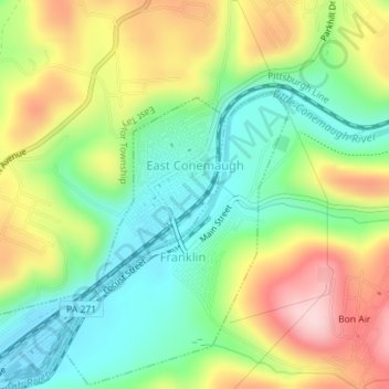
Name: East Conemaugh topographic map, elevation, terrain.
Location: East Conemaugh, Cambria County, Pennsylvania, United States (40.33987 -78.89249 40.35338 -78.88091)
Average elevation: 462 m
Minimum elevation: 363 m
Maximum elevation: 604 m
Make a donation
Gear up for your next adventure:
As an Amazon Associate, this site earns from qualifying purchases at no extra cost to you.
Other topographic maps
Click on a map to view its topography, its elevation and its terrain.
Spangler Reservoir
United States > Pennsylvania > Cambria County > Barr Township
Average elevation: 586 m
Twin Rocks
United States > Pennsylvania > Cambria County > Blacklick Township
Average elevation: 562 m
Parkhill
United States > Pennsylvania > Cambria County > East Taylor Township
Average elevation: 489 m
Mineral Point
United States > Pennsylvania > Cambria County > East Taylor Township
Average elevation: 527 m
Make a donation
Gear up for your next adventure:
As an Amazon Associate, this site earns from qualifying purchases at no extra cost to you.
Make a donation
Gear up for your next adventure:
As an Amazon Associate, this site earns from qualifying purchases at no extra cost to you.
Beaverdale
United States > Pennsylvania > Cambria County > Summerhill Township
Average elevation: 664 m
Make a donation
Gear up for your next adventure:
As an Amazon Associate, this site earns from qualifying purchases at no extra cost to you.
Gallitzin Tunnelhill Park
United States > Pennsylvania > Cambria County > Gallitzin
Average elevation: 682 m
Make a donation
Gear up for your next adventure:
As an Amazon Associate, this site earns from qualifying purchases at no extra cost to you.