
Thank you for supporting this site ❤️
Make a donation
Make a donation
Gear up for your next adventure:
As an Amazon Associate, this site earns from qualifying purchases at no extra cost to you.
Sangkat Tuol Sangkae 2 topographic map
Click on the map to display elevation.
Thank you for supporting this site ❤️
Make a donation
Make a donation
Gear up for your next adventure:
As an Amazon Associate, this site earns from qualifying purchases at no extra cost to you.
About this map
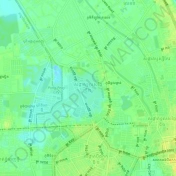
Name: Sangkat Tuol Sangkae 2 topographic map, elevation, terrain.
Location: Sangkat Tuol Sangkae 2, Phnom Penh, 120707, Cambodia (11.57943 104.87560 11.61943 104.91560)
Average elevation: 10 m
Minimum elevation: -1 m
Maximum elevation: 19 m
Thank you for supporting this site ❤️
Make a donation
Make a donation
Gear up for your next adventure:
As an Amazon Associate, this site earns from qualifying purchases at no extra cost to you.
Other topographic maps
Click on a map to view its topography, its elevation and its terrain.