Geolocate

Friendship topographic map

Click on the map to display elevation.

About this map

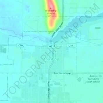
Name: Friendship topographic map, elevation, terrain.

Location: Friendship, Adams County, Wisconsin, United States (43.96683 -89.83794 43.97803 -89.80635)

Average elevation: 295 m

Minimum elevation: 281 m

Maximum elevation: 384 m

Other topographic maps

Click on a map to view its topography, its elevation and its terrain.

Lake Camelot

United States > Wisconsin > Adams County

Average elevation: 312 m

Lake Sherwood

United States > Wisconsin > Adams County

Average elevation: 308 m

Easton

United States > Wisconsin > Adams County

Average elevation: 287 m

Arkdale

United States > Wisconsin > Adams County

Average elevation: 287 m

Grand Marsh

United States > Wisconsin > Adams County

Average elevation: 308 m

White Creek

United States > Wisconsin > Adams County

Average elevation: 274 m

Lake Arrowhead

United States > Wisconsin > Adams County

Average elevation: 302 m

Dellwood

United States > Wisconsin > Adams County

Average elevation: 278 m

Gear up for your next adventure:

🧥Thermal Layer - Insulating layer for cold outdoor conditions
🔋Lithium AA Batteries - Long-lasting power that performs in extreme cold
🧥Thermal Fleece Jacket - Versatile insulation for changing mountain temperatures
💡Compact LED Flashlight - Powerful and portable flashlight for outdoor use
🛌Down Sleeping Bag - Superior warmth-to-weight ratio for cold nights

As an Amazon Associate, this site earns from qualifying purchases at no extra cost to you.