Geolocate

Niedernberg topographic map

Click on the map to display elevation.

About this map

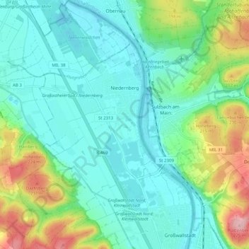
Name: Niedernberg topographic map, elevation, terrain.

Location: Niedernberg, Landkreis Miltenberg, Bavaria, 63843, Germany (49.87426 9.09361 49.93848 9.15327)

Average elevation: 153 m

Minimum elevation: 110 m

Maximum elevation: 276 m

Other topographic maps

Click on a map to view its topography, its elevation and its terrain.

Hobbach

Germany > Bavaria > Landkreis Miltenberg

Average elevation: 299 m

Gear up for your next adventure:

🥾Waterproof Hiking Boots - Essential footwear for rugged terrain and wet Canadian trails
🥾Mountain Hiking Boots - High-traction boots for rocky terrain
🪑Insulated Seat Pad - Protect your seat from cold rocks and wet logs
🔋Solar Power Bank - Keep your GPS and devices charged during long outdoor trips
🔭Compact Binoculars - Lightweight optics for scouting trails and wildlife

As an Amazon Associate, this site earns from qualifying purchases at no extra cost to you.