
Make a donation
Gear up for your next adventure:
As an Amazon Associate, this site earns from qualifying purchases at no extra cost to you.
Kupres topographic map
Click on the map to display elevation.
Make a donation
Gear up for your next adventure:
As an Amazon Associate, this site earns from qualifying purchases at no extra cost to you.
Kupres
Since 2020, Grass mowing competition custom in Kupres ("Strljanica") is inscribed as UNESCO Intangible Cultural Heritage of Humanity. The most important social event in the Kupres municipality is the annual mowing competition that takes place in July at a specific meadow called Strljanica, which is also the local name for the custom. The contest involves the manual mowing of grass using a scythe and is judged by the time, effort and amount mown as cutting grass at that altitude requires strength and a special technique. The top three mowers are recognized, with the chief mower treated as a leader who ensures the successful mowing of all the fields to gather hay for the cattle; agriculture and cattle breeding are essential parts of the area’s economy. Men, starting from the age of eighteen, are traditionally the competitors, with the element being transmitted within families from father to son. Women rake the grass and prepare food for guests. Other elements linked to the competition include national costumes, the forging of scythes and the preparation of cattle for competition. All ethnic and religious groups and individuals in Kupres are free to participate, with the custom being considered as a foundation of the area’s cultural identity, regardless of people’s background. The bearers themselves and the Kupres Mowers Association are most responsible for safeguarding the element.
Make a donation
Gear up for your next adventure:
As an Amazon Associate, this site earns from qualifying purchases at no extra cost to you.
About this map
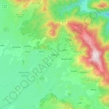
Name: Kupres topographic map, elevation, terrain.
Average elevation: 1,254 m
Minimum elevation: 1,009 m
Maximum elevation: 1,754 m
Make a donation
Gear up for your next adventure:
As an Amazon Associate, this site earns from qualifying purchases at no extra cost to you.
Other topographic maps
Click on a map to view its topography, its elevation and its terrain.
Hubjeri
Bosnia and Herzegovina > Federation of Bosnia and Herzegovina > City of Goražde > Hubjeri
Average elevation: 454 m
Blidinje jezero
Bosnia and Herzegovina > Federation of Bosnia and Herzegovina
It is located at an elevation of 1,185 metres (3,888 ft) above sea level and is 2.5 kilometres (1.6 mi) long and 2.1 kilometres (1.3 mi) wide. Maximal depth of the lake is only 4.5 metres (15 ft), while average depth is around 1 metre (3.3 ft). The lake area varies from 2.5 to 6 km2, and the average depth is…
Average elevation: 1,242 m
Grlovnica
Bosnia and Herzegovina > Federation of Bosnia and Herzegovina > Rastovci
Average elevation: 619 m