Geolocate

Cahuita topographic map

Click on the map to display elevation.

About this map

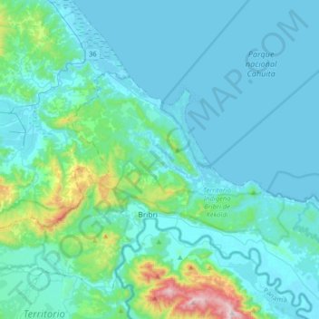
Name: Cahuita topographic map, elevation, terrain.

Location: Cahuita, Cantón Talamanca, Limón Province, 70403, Costa Rica (9.59192 -82.93285 9.76764 -82.61163)

Average elevation: 99 m

Minimum elevation: -1 m

Maximum elevation: 867 m

Other topographic maps

Click on a map to view its topography, its elevation and its terrain.

Catarata

Costa Rica > Cantón Talamanca > Cahuita

Average elevation: 127 m

Gear up for your next adventure:

💧Collapsible Water Bottle - Space-saving water bottle for outdoor activities
👟Leg Gaiters - Keep debris, mud, and snow out of your boots
💡LED Headlamp - Hands-free illumination for night hiking and camping
🔦UV Flashlight - Detect minerals or specific insects in the dark
🧤Insulated Winter Gloves - Heavy-duty protection for sub-zero Canadian adventures

As an Amazon Associate, this site earns from qualifying purchases at no extra cost to you.