
Plandiste Municipality topographic map
Interactive map
Click on the map to display elevation.
About this map
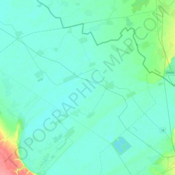
Name: Plandiste Municipality topographic map, elevation, terrain.
Average elevation: 81 m
Minimum elevation: 73 m
Maximum elevation: 140 m
Other topographic maps
Click on a map to view its topography, its elevation and its terrain.
City of Vršac
Serbia > Vojvodina > South Banat Administrative District
City of Vršac, South Banat Administrative District, Vojvodina, Serbia
Average elevation: 119 m
Средњи врх
Serbia > Vojvodina > South Banat Administrative District > City of Vršac
Средњи врх, City of Vršac, South Banat Administrative District, Vojvodina, Serbia
Average elevation: 305 m
Alibunar
Serbia > Vojvodina > South Banat Administrative District > Alibunar Municipality > Alibunar
Alibunar, Alibunar Municipality, South Banat Administrative District, Vojvodina, 26310, Serbia
Average elevation: 101 m
Pancevo City
Serbia > Vojvodina > South Banat Administrative District
Pancevo City, South Banat Administrative District, Vojvodina, Serbia
Average elevation: 102 m