Geolocate

Trinity Center topographic map

Click on the map to display elevation.

About this map

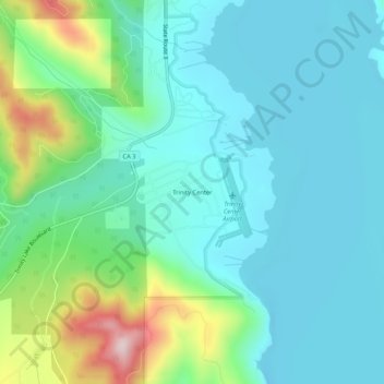
Name: Trinity Center topographic map, elevation, terrain.

Location: Trinity Center, Trinity County, California, 96091, United States (40.96320 -122.71974 41.00320 -122.67974)

Average elevation: 791 m

Minimum elevation: 704 m

Maximum elevation: 1,094 m

Other topographic maps

Click on a map to view its topography, its elevation and its terrain.

Mad River

United States > California > Trinity County

Average elevation: 1,239 m

Shimmy Lake

United States > California > Trinity County

Average elevation: 1,917 m

Summit Lake

United States > California > Trinity County

Average elevation: 2,153 m

Gear up for your next adventure:

🏃Hydration Running Vest - Carry water and maps close to your body for speed
🛶Waterproof Dry Bags - Keep electronics and clothes dry during river crossings
👖Convertible Hiking Pants - Zip-off legs to adapt to changing weather conditions
🧥Thermal Fleece Jacket - Versatile insulation for changing mountain temperatures
🥾Trail Hiking Socks - Comfortable socks to prevent blisters and fatigue

As an Amazon Associate, this site earns from qualifying purchases at no extra cost to you.