
Oakwood Park topographic map
Interactive map
Click on the map to display elevation.
About this map
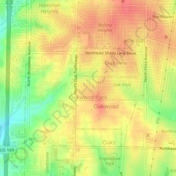
Name: Oakwood Park topographic map, elevation, terrain.
Location: Oakwood Park, Clay County, Missouri, United States (39.20282 -94.57630 39.20657 -94.57173)
Average elevation: 295 m
Minimum elevation: 260 m
Maximum elevation: 316 m
Other topographic maps
Click on a map to view its topography, its elevation and its terrain.
North Kansas City
United States > Missouri > Clay County
North Kansas City, Clay County, Missouri, 64416, United States
Average elevation: 232 m
Northaven
United States > Missouri > Clay County > Gladstone > Northaven
Northaven, Gladstone, Clay County, Missouri, 64118, United States
Average elevation: 293 m