
Huancayo topographic map
Click on the map to display elevation.
About this map
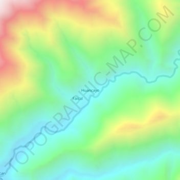
Name: Huancayo topographic map, elevation, terrain.
Location: Huancayo, Distrito de Ayabaca, Ayabaca, Piura, Perú (-4.75311 -79.75870 -4.71311 -79.71870)
Average elevation: 1,404 m
Minimum elevation: 970 m
Maximum elevation: 2,273 m
Other topographic maps
Click on a map to view its topography, its elevation and its terrain.
Área de Conservación Privada Lagunas y Páramos de Andinos de San José de Tapal
Perú > Piura > Distrito de Ayabaca
Average elevation: 3,353 m