Geolocate

Le Gollet topographic map

Click on the map to display elevation.

About this map
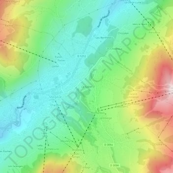
Name: Le Gollet topographic map, elevation, terrain.

Location: Le Gollet, Megève, Bonneville, Haute-Savoie, Auvergne-Rhône-Alpes, France métropolitaine, 74120, France (45.83908 6.60832 45.87908 6.64832)

Average elevation: 1,289 m

Minimum elevation: 1,044 m

Maximum elevation: 1,775 m

Other topographic maps

Click on a map to view its topography, its elevation and its terrain.
74120

France > Auvergne-Rhône-Alpes > Haute-Savoie > Megève > Les Granges

Average elevation: 1,284 m

Lac de Javen

France > Auvergne-Rhône-Alpes > Haute-Savoie > Megève

Average elevation: 1,489 m

Gear up for your next adventure:

🩹Compact First Aid Kit - Pre-packed essentials for common trail injuries
🔦LED Headlamp - Hands-free lighting for early morning starts or late finishes
🥽Outdoor Goggles - Protective eyewear for outdoor activities
🧭GPS Outdoor Watch - Smart watch for navigation and fitness tracking in nature
🛶Waterproof Dry Bags - Keep electronics and clothes dry during river crossings

As an Amazon Associate, this site earns from qualifying purchases at no extra cost to you.