
Ourinhos topographic map
Click on the map to display elevation.
Ourinhos
Ourinhos is a municipality in the state of São Paulo in Brazil. The population is 114,352 (2020 est.) in an area of 295.82 km2 (114.22 sq mi). The elevation is 483 metres (1,585 ft).
About this map
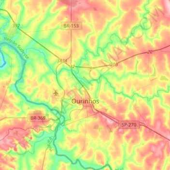
Name: Ourinhos topographic map, elevation, terrain.
Average elevation: 449 m
Minimum elevation: 367 m
Maximum elevation: 547 m
Other topographic maps
Click on a map to view its topography, its elevation and its terrain.
Jardim Copacabana
Brazil > São Paulo > Região Metropolitana de São Paulo > São Paulo
Average elevation: 792 m