
Blue River topographic map
Click on the map to display elevation.
About this map
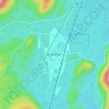
Name: Blue River topographic map, elevation, terrain.
Average elevation: 710 m
Minimum elevation: 664 m
Maximum elevation: 957 m
Thompson-Nicola Regional District trails, hiking, mountain biking, running and outdoor activities
Other topographic maps
Click on a map to view its topography, its elevation and its terrain.
Blue River
Canada > British Columbia > Thompson-Nicola Regional District > Area B (Thompson Headwaters)
Average elevation: 1,431 m
Eleanor Lake
Canada > British Columbia > Thompson-Nicola Regional District > Area B (Thompson Headwaters) > Blue River
Average elevation: 695 m
Thompson Glacier
Canada > British Columbia > Thompson-Nicola Regional District > Area B (Thompson Headwaters)
Average elevation: 2,313 m
Blackstone Glacier
Canada > British Columbia > Thompson-Nicola Regional District > Area B (Thompson Headwaters)
Average elevation: 2,368 m