Geolocate

Mallassery topographic map

Click on the map to display elevation.

About this map

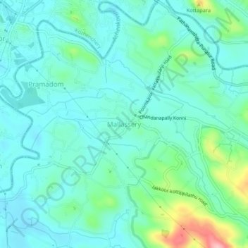
Name: Mallassery topographic map, elevation, terrain.

Location: Mallassery, Konni, Pathanamthitta, Kerala, 689646, India (9.22143 76.78220 9.26143 76.82220)

Average elevation: 41 m

Minimum elevation: 9 m

Maximum elevation: 167 m

Gear up for your next adventure:

🧥Thermal Fleece Jacket - Versatile insulation for changing mountain temperatures
🧰Survival Kit - Essential gear for emergencies in the wilderness
🧥Insulated Jacket - Keep warm in cold outdoor conditions
🦶Anti-Blister Balm - Prevents friction and hotspots during long ascents
💡Solar Camping Lamp - Eco-friendly lighting for campsites

As an Amazon Associate, this site earns from qualifying purchases at no extra cost to you.