
Make a donation
Gear up for your next adventure:
As an Amazon Associate, this site earns from qualifying purchases at no extra cost to you.
Rottenmann topographic map
Click on the map to display elevation.
Make a donation
Gear up for your next adventure:
As an Amazon Associate, this site earns from qualifying purchases at no extra cost to you.
About this map
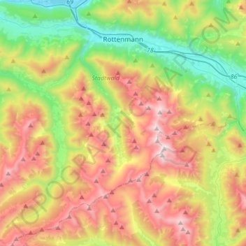
Name: Rottenmann topographic map, elevation, terrain.
Location: Rottenmann, Bezirk Liezen, Styrie, 8786, Autriche (47.37018 14.20712 47.55301 14.47523)
Average elevation: 1,389 m
Minimum elevation: 623 m
Maximum elevation: 2,418 m
Make a donation
Gear up for your next adventure:
As an Amazon Associate, this site earns from qualifying purchases at no extra cost to you.
Other topographic maps
Click on a map to view its topography, its elevation and its terrain.
Planneralm
Autriche > Styrie > Bezirk Liezen > Irdning-Donnersbachtal > Planneralm
Average elevation: 1,747 m
Kienach
Autriche > Styrie > Bezirk Liezen > Irdning-Donnersbachtal > Altirdning > Kienach
Average elevation: 886 m