
Harrow topographic map
Click on the map to display elevation.
About this map
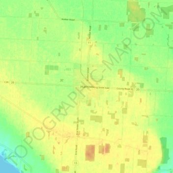
Name: Harrow topographic map, elevation, terrain.
Average elevation: 189 m
Minimum elevation: 172 m
Maximum elevation: 201 m
Essex County trails, hiking, mountain biking, running and outdoor activities
Other topographic maps
Click on a map to view its topography, its elevation and its terrain.
Lakeshore
Canada > Ontario > Essex County
As in the rest of Essex County and Chatham-Kent, the terrain is extremely flat and regular. The terrain slopes very gently from the southern border of Lakeshore on Highway 8, with an average elevation of 188 m (617 ft), to the shore of Lake St. Clair at 176 m (577 ft). The highest land is in the southwestern…
Average elevation: 183 m