Geolocate

Ebbetts Pass topographic map

Click on the map to display elevation.

About this map

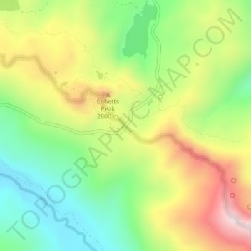
Name: Ebbetts Pass topographic map, elevation, terrain.

Location: Ebbetts Pass, Alpine County, CAL Fire Northern Region, California, United States (38.54426 -119.81196 38.54436 -119.81186)

Average elevation: 2,632 m

Minimum elevation: 2,383 m

Maximum elevation: 2,962 m

Other topographic maps

Click on a map to view its topography, its elevation and its terrain.

Caples Lake

United States > California > Alpine County

Average elevation: 2,450 m

Bear Valley

United States > California > Alpine County

Bear Valley's central Sierra location and elevation gives it a warm-summer Mediterranean climate that is nearly a subarctic climate. Precipitation is seen for a lot of the year except for the middle of the summer, which can experience rare, but not unseen, thunderstorms. Late fall to early spring brings in…

Average elevation: 2,280 m

Lake Alpine

United States > California > Alpine County

Average elevation: 2,283 m

Half Moon Lake

United States > California > Alpine County

Average elevation: 2,643 m

Gear up for your next adventure:

🧤Thermal Hiking Gloves - Grip-enhanced gloves for cold-weather altitude trekking
🚲Heavy Duty Bike Lock - Secure your bike at the trailhead or during stops
🥫Freeze-Dried Meals - Lightweight, high-calorie nutrition for multi-day treks
🥾Trekking Poles - Adjustable trekking poles to reduce knee stress and improve stability
🍽️Titanium Camping Spork - Ultralight and indestructible eating utensil

As an Amazon Associate, this site earns from qualifying purchases at no extra cost to you.