Geolocate

Las Ermitas topographic map

Click on the map to display elevation.

About this map

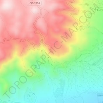
Name: Las Ermitas topographic map, elevation, terrain.

Location: Las Ermitas, Córdoba, Andalucía, 14012, España (37.90609 -4.83421 37.92609 -4.81421)

Average elevation: 354 m

Minimum elevation: 144 m

Maximum elevation: 584 m

Other topographic maps

Click on a map to view its topography, its elevation and its terrain.

Parque Cruz Conde

España > Andalucía > Córdoba

Average elevation: 108 m

Ciudad Jardín

España > Andalucía > Córdoba

Average elevation: 118 m

Las Jaras

España > Andalucía > Córdoba

Average elevation: 476 m

Gear up for your next adventure:

🧊Insulated Water Bottle - Keeps drinks cold in summer and prevents freezing in winter
🧰Survival Kit - Essential gear for emergencies in the wilderness
🧢Outdoor Cap - Protective cap for sun and rain during hikes
🥾Lightweight Hiking Shoes - Comfortable shoes for day hikes
🥾Durable Hiking Shoes - Long-lasting shoes for frequent hiking

As an Amazon Associate, this site earns from qualifying purchases at no extra cost to you.