
Thank you for supporting this site ❤️
Make a donation
Make a donation
Gear up for your next adventure:
As an Amazon Associate, this site earns from qualifying purchases at no extra cost to you.
Katghora topographic map
Click on the map to display elevation.
Thank you for supporting this site ❤️
Make a donation
Make a donation
Gear up for your next adventure:
As an Amazon Associate, this site earns from qualifying purchases at no extra cost to you.
About this map
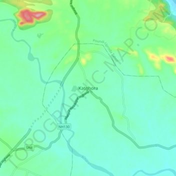
Name: Katghora topographic map, elevation, terrain.
Location: Katghora, Katghora Tahsil, Korba, Chhattisgarh, 495445, India (22.46962 82.51076 22.54962 82.59076)
Average elevation: 331 m
Minimum elevation: 294 m
Maximum elevation: 467 m
Thank you for supporting this site ❤️
Make a donation
Make a donation
Gear up for your next adventure:
As an Amazon Associate, this site earns from qualifying purchases at no extra cost to you.