
Make a donation
Gear up for your next adventure:
As an Amazon Associate, this site earns from qualifying purchases at no extra cost to you.
Curahuara de Carangas topographic map
Click on the map to display elevation.
Make a donation
Gear up for your next adventure:
As an Amazon Associate, this site earns from qualifying purchases at no extra cost to you.
About this map
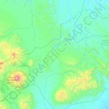
Name: Curahuara de Carangas topographic map, elevation, terrain.
Location: Curahuara de Carangas, Sajama, Oruro, Bolivia (-18.27097 -69.14584 -17.59052 -68.29029)
Average elevation: 4,042 m
Minimum elevation: 3,767 m
Maximum elevation: 5,069 m
Make a donation
Gear up for your next adventure:
As an Amazon Associate, this site earns from qualifying purchases at no extra cost to you.
Other topographic maps
Click on a map to view its topography, its elevation and its terrain.
Nevado Sajama
Bolivia > Oruro > Sajama > Curahuara de Carangas
The mountain is covered by an ice cap, and Polylepis tarapacana trees occur up to 5,000 metres (16,000 ft) elevation.
Average elevation: 5,771 m