
Thank you for supporting this site ❤️
Make a donation
Make a donation
Gear up for your next adventure:
As an Amazon Associate, this site earns from qualifying purchases at no extra cost to you.
Jöchlspitze topographic map
Click on the map to display elevation.
Thank you for supporting this site ❤️
Make a donation
Make a donation
Gear up for your next adventure:
As an Amazon Associate, this site earns from qualifying purchases at no extra cost to you.
About this map
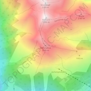
Name: Jöchlspitze topographic map, elevation, terrain.
Location: Jöchlspitze, Holzgau, Bezirk Reutte, Tirol, 6654, Österreich (47.28168 10.35902 47.28178 10.35912)
Average elevation: 1,806 m
Minimum elevation: 1,184 m
Maximum elevation: 2,359 m
Thank you for supporting this site ❤️
Make a donation
Make a donation
Gear up for your next adventure:
As an Amazon Associate, this site earns from qualifying purchases at no extra cost to you.