
Make a donation
Gear up for your next adventure:
As an Amazon Associate, this site earns from qualifying purchases at no extra cost to you.
Viladecavalls topographic map
Click on the map to display elevation.
Make a donation
Gear up for your next adventure:
As an Amazon Associate, this site earns from qualifying purchases at no extra cost to you.
About this map
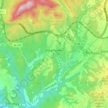
Name: Viladecavalls topographic map, elevation, terrain.
Average elevation: 290 m
Minimum elevation: 105 m
Maximum elevation: 627 m
Make a donation
Gear up for your next adventure:
As an Amazon Associate, this site earns from qualifying purchases at no extra cost to you.
Other topographic maps
Click on a map to view its topography, its elevation and its terrain.
Rubí
Espagne > Catalogne > Vallais-Occidental > Rubí > Rubí
Située à 134 mètres d'altitude, la ville de Rubí a pour coordonnées géographiques Latitude: 41° 29' 32'' Nord et Longitude: 2° 1' 53'' Est. Elle est longée par les autoroutes AP-7 (E- 15) et C-16 et se trouve a Nord-Ouest de Barcelone, à une vingtaine de kilomètres de la capitale Catalane.
Average elevation: 173 m