
Parishville topographic map
Interactive map
Click on the map to display elevation.
About this map
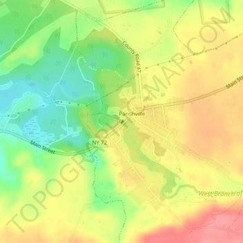
Name: Parishville topographic map, elevation, terrain.
Average elevation: 265 m
Minimum elevation: 220 m
Maximum elevation: 305 m
Other topographic maps
Click on a map to view its topography, its elevation and its terrain.
The Rock
Estados Unidos > Nueva York > Chippewa Bay
The Rock, Chippewa Bay, Saint Lawrence County, Nueva York, Estados Unidos
Average elevation: 76 m
Todt Hill
Estados Unidos > Nueva York > Nueva York
Todt Hill, Staten Island, Richmond County, Nueva York, 10304, Estados Unidos
Average elevation: 75 m
New York County
Estados Unidos > Nueva York > Nueva York
New York County, Nueva York, Estados Unidos
Average elevation: 16 m