
Make a donation
Gear up for your next adventure:
As an Amazon Associate, this site earns from qualifying purchases at no extra cost to you.
Le Vésinet topographic map
Click on the map to display elevation.
Make a donation
Gear up for your next adventure:
As an Amazon Associate, this site earns from qualifying purchases at no extra cost to you.
Le Vésinet
The terrain is an alluvial plain ranging in altitude from 28 meters near Le Pecq to 45 meters at the end of the Route de Montesson, with a gentle slope from northeast to southwest.
Make a donation
Gear up for your next adventure:
As an Amazon Associate, this site earns from qualifying purchases at no extra cost to you.
About this map
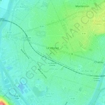
Name: Le Vésinet topographic map, elevation, terrain.
Average elevation: 37 m
Minimum elevation: 17 m
Maximum elevation: 92 m
Make a donation
Gear up for your next adventure:
As an Amazon Associate, this site earns from qualifying purchases at no extra cost to you.
Other topographic maps
Click on a map to view its topography, its elevation and its terrain.
Le Champtier des Fourneaux
France > Ile-de-France > Yvelines > Dampierre-en-Yvelines
Average elevation: 143 m
Make a donation
Gear up for your next adventure:
As an Amazon Associate, this site earns from qualifying purchases at no extra cost to you.
Val des Quatre Pignons
France > Ile-de-France > Yvelines > Beynes > Val des Quatre Pignons
Average elevation: 92 m
Make a donation
Gear up for your next adventure:
As an Amazon Associate, this site earns from qualifying purchases at no extra cost to you.