
Make a donation
Gear up for your next adventure:
As an Amazon Associate, this site earns from qualifying purchases at no extra cost to you.
Alpes-de-Haute-Provence topographic map
Click on the map to display elevation.
Make a donation
Gear up for your next adventure:
As an Amazon Associate, this site earns from qualifying purchases at no extra cost to you.
Alpes-de-Haute-Provence
The climate of the Alpes-de-Haute-Provence department is a Mediterranean climate degrading by altitude and latitude. In fact, while in the lower valleys and flat lands of Haute-Provence an inland Mediterranean climate prevails, by contrast in the hills it is more mixed with the valley of the Ubaye characteristic of the inner Alps, with a marked continentality: winters are very harsh with stormy summers. In between, the two influences mingle in the area of the Lower Alps. The characteristics of both climate trends are found throughout the department to a greater or lesser extent.
Make a donation
Gear up for your next adventure:
As an Amazon Associate, this site earns from qualifying purchases at no extra cost to you.
About this map
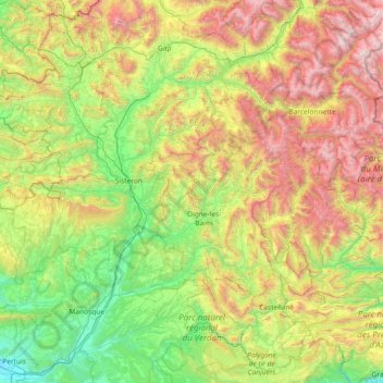
Name: Alpes-de-Haute-Provence topographic map, elevation, terrain.
Average elevation: 1,141 m
Minimum elevation: 177 m
Maximum elevation: 3,366 m
Make a donation
Gear up for your next adventure:
As an Amazon Associate, this site earns from qualifying purchases at no extra cost to you.
Other topographic maps
Click on a map to view its topography, its elevation and its terrain.
Aix-en-Provence
France > Provence-Alpes-Côte d'Azur > Bouches-du-Rhône > Aix-en-Provence
Average elevation: 279 m
La Grave de Peille
France > Provence-Alpes-Côte d'Azur > Maritime Alps > Peille
Average elevation: 400 m
Make a donation
Gear up for your next adventure:
As an Amazon Associate, this site earns from qualifying purchases at no extra cost to you.
Le Revest-les-Eaux
France > Provence-Alpes-Côte d'Azur > Var > Le Revest-les-Eaux > Le Revest-les-Eaux
Average elevation: 327 m
Make a donation
Gear up for your next adventure:
As an Amazon Associate, this site earns from qualifying purchases at no extra cost to you.
Le Suquet
France > Provence-Alpes-Côte d'Azur > Maritime Alps > Lantosque > Le Suquet
Average elevation: 669 m