
Make a donation
Gear up for your next adventure:
As an Amazon Associate, this site earns from qualifying purchases at no extra cost to you.
Raderach topographic map
Click on the map to display elevation.
Make a donation
Gear up for your next adventure:
As an Amazon Associate, this site earns from qualifying purchases at no extra cost to you.
About this map
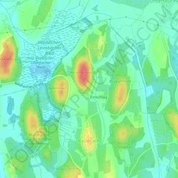
Name: Raderach topographic map, elevation, terrain.
Average elevation: 449 m
Minimum elevation: 429 m
Maximum elevation: 495 m
Make a donation
Gear up for your next adventure:
As an Amazon Associate, this site earns from qualifying purchases at no extra cost to you.
Other topographic maps
Click on a map to view its topography, its elevation and its terrain.
Batzenweiler
Deutschland > Baden-Württemberg > Bodenseekreis > Friedrichshafen > Ettenkirch
Average elevation: 470 m
Oberlottenweiler
Deutschland > Baden-Württemberg > Bodenseekreis > Friedrichshafen
Average elevation: 456 m
Schlosshorn
Deutschland > Baden-Württemberg > Bodenseekreis > Friedrichshafen
Average elevation: 400 m
Make a donation
Gear up for your next adventure:
As an Amazon Associate, this site earns from qualifying purchases at no extra cost to you.
Appenweiler
Deutschland > Baden-Württemberg > Bodenseekreis > Friedrichshafen > Appenweiler
Average elevation: 456 m