
Make a donation
Gear up for your next adventure:
As an Amazon Associate, this site earns from qualifying purchases at no extra cost to you.
Zerf topographic map
Click on the map to display elevation.
Make a donation
Gear up for your next adventure:
As an Amazon Associate, this site earns from qualifying purchases at no extra cost to you.
Zerf
Zerf liegt am Großbach und an der Ruwer im Naturpark Saar-Hunsrück in waldreicher Höhenlage. Bei Zerf verläuft der Ruwer-Hochwald-Radweg auf der Trasse der ehemaligen Hochwaldbahn.
Make a donation
Gear up for your next adventure:
As an Amazon Associate, this site earns from qualifying purchases at no extra cost to you.
About this map
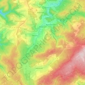
Name: Zerf topographic map, elevation, terrain.
Average elevation: 471 m
Minimum elevation: 280 m
Maximum elevation: 658 m
Make a donation
Gear up for your next adventure:
As an Amazon Associate, this site earns from qualifying purchases at no extra cost to you.
Other topographic maps
Click on a map to view its topography, its elevation and its terrain.