
Make a donation
Gear up for your next adventure:
As an Amazon Associate, this site earns from qualifying purchases at no extra cost to you.
Neuhausen topographic map
Click on the map to display elevation.
Make a donation
Gear up for your next adventure:
As an Amazon Associate, this site earns from qualifying purchases at no extra cost to you.
About this map
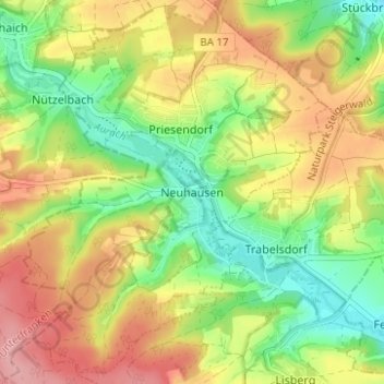
Name: Neuhausen topographic map, elevation, terrain.
Average elevation: 331 m
Minimum elevation: 272 m
Maximum elevation: 395 m
Make a donation
Gear up for your next adventure:
As an Amazon Associate, this site earns from qualifying purchases at no extra cost to you.
Other topographic maps
Click on a map to view its topography, its elevation and its terrain.
Make a donation
Gear up for your next adventure:
As an Amazon Associate, this site earns from qualifying purchases at no extra cost to you.
Litzendorf
Germany > Bavaria > Landkreis Bamberg
Litzendorf and most of its outlying centres lie in the Ellern Valley, which is surrounded by wooded heights with the Bamberg district's two highest elevations, the Geisberg (585 m) and the Stammberg (560 m).
Average elevation: 362 m
Make a donation
Gear up for your next adventure:
As an Amazon Associate, this site earns from qualifying purchases at no extra cost to you.
Make a donation
Gear up for your next adventure:
As an Amazon Associate, this site earns from qualifying purchases at no extra cost to you.
Heiligenstadt i. OFr.
Germany > Bavaria > Landkreis Bamberg
Heiligenstadt lies in the Bamberg district’s southeastern corner. The 24 Gemeindeteile lie along the Leinleiter Valley and on the abutting Jura Plateau. Veilbronn lies 329 m above sea level. The greatest elevation is the Altenberg (mountain) behind Zoggendorf at 583 m above sea level. The villages on the…
Average elevation: 468 m
Make a donation
Gear up for your next adventure:
As an Amazon Associate, this site earns from qualifying purchases at no extra cost to you.