
Make a donation
Gear up for your next adventure:
As an Amazon Associate, this site earns from qualifying purchases at no extra cost to you.
Hohengöhren topographic map
Click on the map to display elevation.
Make a donation
Gear up for your next adventure:
As an Amazon Associate, this site earns from qualifying purchases at no extra cost to you.
Hohengöhren
Im Jahr 1479 wird Jung Frytz von Mollendorf zu Hoen Gorne genannt. Auch 1564 gehört der Ort den von Möllendorf, genauso wie 1782. Ende des 18. Jahrhunderts begann die Urbarmachung des Trüben, eines östlich des Dorfes gelegen Bruchs. Dabei wurden der Gutsherrschaft Höhengöhren 316 Morgen an Acker, Wiesen und Weiden verbessert und 558 Morgen urbar gemacht.
Make a donation
Gear up for your next adventure:
As an Amazon Associate, this site earns from qualifying purchases at no extra cost to you.
About this map
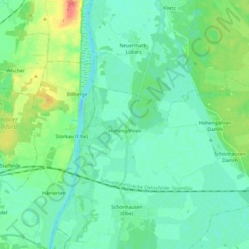
Name: Hohengöhren topographic map, elevation, terrain.
Average elevation: 36 m
Minimum elevation: 24 m
Maximum elevation: 76 m
Make a donation
Gear up for your next adventure:
As an Amazon Associate, this site earns from qualifying purchases at no extra cost to you.