
Make a donation
Gear up for your next adventure:
As an Amazon Associate, this site earns from qualifying purchases at no extra cost to you.
Edgecliff Village topographic map
Click on the map to display elevation.
Make a donation
Gear up for your next adventure:
As an Amazon Associate, this site earns from qualifying purchases at no extra cost to you.
About this map
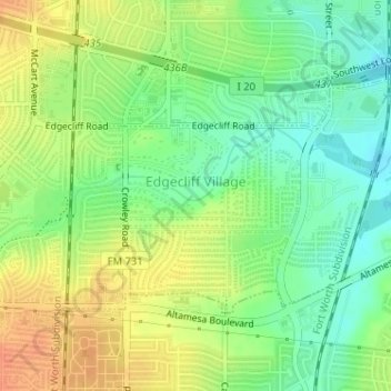
Name: Edgecliff Village topographic map, elevation, terrain.
Location: Edgecliff Village, Tarrant County, Texas, United States (32.64853 -97.35335 32.66472 -97.32693)
Average elevation: 219 m
Minimum elevation: 199 m
Maximum elevation: 240 m
Make a donation
Gear up for your next adventure:
As an Amazon Associate, this site earns from qualifying purchases at no extra cost to you.
Other topographic maps
Click on a map to view its topography, its elevation and its terrain.
Summerfields/Chisholm Park
United States > Texas > Tarrant County > Fort Worth
Average elevation: 203 m
Make a donation
Gear up for your next adventure:
As an Amazon Associate, this site earns from qualifying purchases at no extra cost to you.
Make a donation
Gear up for your next adventure:
As an Amazon Associate, this site earns from qualifying purchases at no extra cost to you.
Make a donation
Gear up for your next adventure:
As an Amazon Associate, this site earns from qualifying purchases at no extra cost to you.
Make a donation
Gear up for your next adventure:
As an Amazon Associate, this site earns from qualifying purchases at no extra cost to you.
Will Rogers Memorial Center
United States > Texas > Tarrant County > Fort Worth
Average elevation: 181 m