Geolocate

Krueng Raya topographic map

Click on the map to display elevation.

About this map

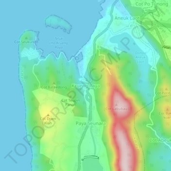
Name: Krueng Raya topographic map, elevation, terrain.

Location: Krueng Raya, Sabang, Aceh, Sumatra, 23513, Indonesia (5.84111 95.29722 5.88111 95.33722)

Average elevation: 92 m

Minimum elevation: 0 m

Maximum elevation: 381 m

Other topographic maps

Click on a map to view its topography, its elevation and its terrain.

Pulau Weh

Indonesia > Aceh > Sabang

Average elevation: 46 m

Pulau Weh

Indonesia > Aceh > Sabang

Average elevation: 46 m

Gear up for your next adventure:

💧Hydration Bladder - Hands-free hydration solution for long treks
🔨Vehicle Emergency Tool - Safety tool for remote road trips to trailheads
🩹Moleskin Blister Pads - Direct protection for painful foot pressure points
🪑Ultralight Camping Stool - Compact seating for rest stops during long hikes
💡LED Camping Lantern - Illuminate your campsite with long-lasting lanterns

As an Amazon Associate, this site earns from qualifying purchases at no extra cost to you.