Geolocate

Oroville topographic map

Click on the map to display elevation.

About this map

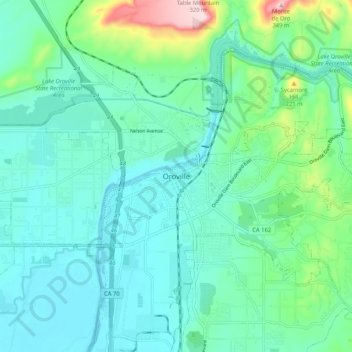
Name: Oroville topographic map, elevation, terrain.

Location: Oroville, Butte County, California, 95965, United States (39.47378 -121.59636 39.55378 -121.51636)

Average elevation: 96 m

Minimum elevation: 34 m

Maximum elevation: 343 m

Gear up for your next adventure:

👟Leg Gaiters - Keep debris, mud, and snow out of your boots
🧥Softshell Hiking Jacket - The perfect balance of wind protection and breathability
Lightweight Backpacking Tent - Compact tent for efficient hiking trips
🧥Waterproof Hiking Jacket - Protect yourself from rain and wind while hiking
🧢Hiking Hat - Sun-protective and breathable hats for long treks

As an Amazon Associate, this site earns from qualifying purchases at no extra cost to you.