
Guilin topographic map
Interactive map
Click on the map to display elevation.
About this map
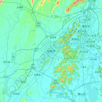
Name: Guilin topographic map, elevation, terrain.
Location: Guilin, Guangxi, China (25.07832 110.01522 25.39832 110.33522)
Average elevation: 177 m
Minimum elevation: 138 m
Maximum elevation: 589 m
Guilin (Standard Zhuang: Gveilinz; alternatively romanized as Kweilin) is a prefecture-level city in the northeast of China's Guangxi Zhuang Autonomous Region. It is situated on the west bank of the Li River and borders Hunan to the north. Its name means "forest of sweet osmanthus", owing to the large number of fragrant sweet osmanthus trees located in the region. The city has long been renowned for its scenery of karst topography.
Other topographic maps
Click on a map to view its topography, its elevation and its terrain.
Lingchuan County
Lingchuan County, Guilin, Guangxi, 541203, China
Average elevation: 431 m