
Make a donation
Gear up for your next adventure:
As an Amazon Associate, this site earns from qualifying purchases at no extra cost to you.
Lingchuan County topographic map
Click on the map to display elevation.
Make a donation
Gear up for your next adventure:
As an Amazon Associate, this site earns from qualifying purchases at no extra cost to you.
About this map
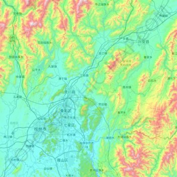
Name: Lingchuan County topographic map, elevation, terrain.
Location: Lingchuan County, Guilin, Guangxi, 541203, China (25.02952 110.08853 25.79022 110.78516)
Average elevation: 431 m
Minimum elevation: 126 m
Maximum elevation: 1,698 m
Make a donation
Gear up for your next adventure:
As an Amazon Associate, this site earns from qualifying purchases at no extra cost to you.
Other topographic maps
Click on a map to view its topography, its elevation and its terrain.
Guilin
Guilin (Standard Zhuang: Gveilinz; alternatively romanized as Kweilin) is a prefecture-level city in the northeast of China's Guangxi Zhuang Autonomous Region. It is situated on the west bank of the Li River and borders Hunan to the north. Its name means "forest of sweet osmanthus", owing to the large number…
Average elevation: 177 m