Geolocate

Angat topographic map

Click on the map to display elevation.

About this map

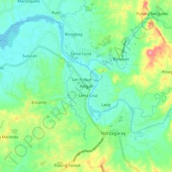
Name: Angat topographic map, elevation, terrain.

Location: Angat, Bulacan, Central Luzon, 3012, Philippines (14.88779 120.98914 14.96779 121.06914)

Average elevation: 53 m

Minimum elevation: 17 m

Maximum elevation: 144 m

Other topographic maps

Click on a map to view its topography, its elevation and its terrain.

Liciada

Philippines > Bulacan > Bustos

Average elevation: 21 m

Encanto

Philippines > Bulacan

Average elevation: 58 m

Malawak

Philippines > Bulacan > Bustos

Average elevation: 34 m

Angat Dam

Philippines > Bulacan

Average elevation: 254 m

Buisan

Philippines > Bulacan > Bustos

Average elevation: 17 m

Ciudad de Victoria

Philippines > Bulacan > Bocaue

Average elevation: 11 m

San Miguel

Philippines > Bulacan

Average elevation: 36 m

Balagtas River

Philippines > Bulacan > Balagtas

Average elevation: 7 m

Cambaog

Philippines > Bulacan > Bustos

Average elevation: 14 m

Pulilan

Philippines > Bulacan

The municipality is generally of flat topography. Eleven (11) of its barangays are bounded by the Angat River. The rest are flat irrigated rice lands. Soil types vary from sandy loam to clay loam which makes the municipality suitable to a wide range of agricultural products.

Average elevation: 10 m

Poblacion

Philippines > Bulacan > Bustos

Average elevation: 17 m

Bulakan

Philippines > Bulacan > Bulakan

Average elevation: 4 m

Calumpit

Philippines > Bulacan > Calumpit

Average elevation: 4 m

Gear up for your next adventure:

🥾Light Hiking Boots - Lightweight and comfortable boots for day hikes
🧢Hiking Hat - Sun-protective and breathable hats for long treks
Camping Coffee Maker - Brew fresh coffee anywhere on the topographic map
Camping Groundsheet - Protect your tent from moisture and dirt
🕶️Polarized Sunglasses - Protect your eyes with durable polarized lenses

As an Amazon Associate, this site earns from qualifying purchases at no extra cost to you.