
Thank you for supporting this site ❤️
Make a donation
Make a donation
Gear up for your next adventure:
As an Amazon Associate, this site earns from qualifying purchases at no extra cost to you.
Agadir topographic map
Click on the map to display elevation.
Thank you for supporting this site ❤️
Make a donation
Make a donation
Gear up for your next adventure:
As an Amazon Associate, this site earns from qualifying purchases at no extra cost to you.
About this map
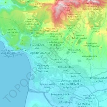
Name: Agadir topographic map, elevation, terrain.
Location: Agadir, Agadir Ida-Outanane Prefecture, Souss-Massa, Morocco (30.35072 -9.67659 30.49336 -9.48407)
Average elevation: 132 m
Minimum elevation: -2 m
Maximum elevation: 821 m
Thank you for supporting this site ❤️
Make a donation
Make a donation
Gear up for your next adventure:
As an Amazon Associate, this site earns from qualifying purchases at no extra cost to you.