Geolocate

Cobriza topographic map

Click on the map to display elevation.

About this map

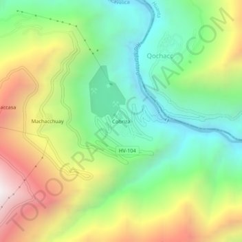
Name: Cobriza topographic map, elevation, terrain.

Location: Cobriza, San Pedro de Coris, Churcampa, Huancavelica, Perú (-12.61508 -74.39107 -12.57508 -74.35107)

Average elevation: 2,569 m

Minimum elevation: 1,905 m

Maximum elevation: 3,605 m

Gear up for your next adventure:

🧢Sun Hat - Wide-brim hat for sun protection
🔥Camping Stove - Portable stoves to cook outdoors with ease
🥾Trekking Boots - Durable boots for long-distance trekking
🔥Emergency Fire Starter - Reliable ignition source for all weather conditions
🧢Outdoor Visor - Breathable visor for sunny hikes

As an Amazon Associate, this site earns from qualifying purchases at no extra cost to you.