
Make a donation
Gear up for your next adventure:
As an Amazon Associate, this site earns from qualifying purchases at no extra cost to you.
Col de la Pierre Saint-Martin topographic map
Click on the map to display elevation.
Make a donation
Gear up for your next adventure:
As an Amazon Associate, this site earns from qualifying purchases at no extra cost to you.
Col de la Pierre Saint-Martin
Col de la Pierre Saint-Martin (elevation 1,766 m (5,794 ft)) is a mountain pass on the France-Spain border in the western Pyrenees in the department of Pyrénées-Atlantiques (France) and Navarra (Spain). The climb from the Spanish side was used in the 2007 Tour de France.
Make a donation
Gear up for your next adventure:
As an Amazon Associate, this site earns from qualifying purchases at no extra cost to you.
About this map
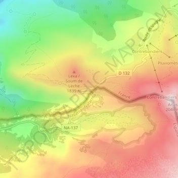
Name: Col de la Pierre Saint-Martin topographic map, elevation, terrain.
Average elevation: 1,695 m
Minimum elevation: 1,349 m
Maximum elevation: 2,004 m
Make a donation
Gear up for your next adventure:
As an Amazon Associate, this site earns from qualifying purchases at no extra cost to you.