Geolocate

Surprise topographic map

Click on the map to display elevation.

About this map

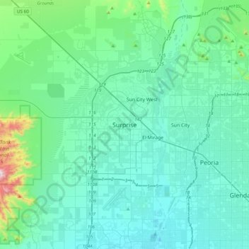
Name: Surprise topographic map, elevation, terrain.

Location: Surprise, Maricopa County, Arizona, 85374, United States (33.46923 -112.52802 33.78923 -112.20802)

Average elevation: 410 m

Minimum elevation: 294 m

Maximum elevation: 1,212 m

Other topographic maps

Click on a map to view its topography, its elevation and its terrain.

Gear up for your next adventure:

🛏️Sleeping Bag - Warm and compact sleeping bags for outdoor camping
🧢Hiking Sun Hat - Wide-brimmed protection for exposed mountain ridges
🚑Survival Whistle - Signal for help across long distances in mountains
🧢Outdoor Visor - Breathable visor for sunny hikes
🦯Trekking Poles - Reduced impact on joints for steep topographic climbs

As an Amazon Associate, this site earns from qualifying purchases at no extra cost to you.