Geolocate

Wrangell topographic map

Click on the map to display elevation.

About this map

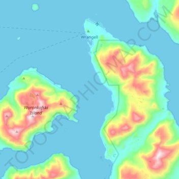
Name: Wrangell topographic map, elevation, terrain.

Location: Wrangell, Alaska, 99929, United States (56.32493 -132.43754 56.50817 -132.19751)

Average elevation: 164 m

Minimum elevation: -5 m

Maximum elevation: 976 m

Other topographic maps

Click on a map to view its topography, its elevation and its terrain.

Wrangell

United States > Alaska > Wrangell

Average elevation: 164 m

Wrangell

United States > Alaska > Wrangell > Wrangell

Average elevation: 79 m

Gear up for your next adventure:

Tent Footprint - Protect tent floor and increase durability
🛶Kayak Accessories - Essential gear for safe and fun kayaking adventures
💧Hydration Bladder - Hands-free hydration solution for long treks
🔪Outdoor Multitool - Versatile tool for repairs and food prep in the wild
🛁Quick-Dry Microfiber Towel - Space-saving towel that dries rapidly on the move

As an Amazon Associate, this site earns from qualifying purchases at no extra cost to you.