Geolocate

Silao topographic map

Click on the map to display elevation.

Silao

Silao is located in the Mexican state of Guanajuato. It is situated 100° 25´ 59´´ longitude west of the Greenwich meridian and 20° 56' 24 latitude north. Its altitude is 1,780 meters above sea level.

Wikipedia (CC-BY-SA 3.0)

About this map

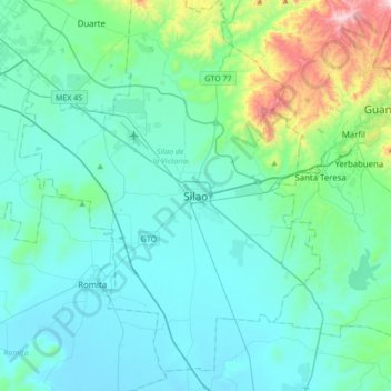
Name: Silao topographic map, elevation, terrain.

Location: Silao, Silao (Ciudad), Silao de la Victoria, Guanajuato, 36100, Mexico (20.78373 -101.58704 21.10373 -101.26704)

Average elevation: 1,877 m

Minimum elevation: 1,735 m

Maximum elevation: 2,705 m

Gear up for your next adventure:

🩹Moleskin Blister Pads - Direct protection for painful foot pressure points
🛌Down Sleeping Bag - Superior warmth-to-weight ratio for cold nights
🧥Thermal Fleece Jacket - Versatile insulation for changing mountain temperatures
🥾Trail Running Shoes - Lightweight and durable shoes for trail running
🛏️Sleeping Bag - Warm and compact sleeping bags for outdoor camping

As an Amazon Associate, this site earns from qualifying purchases at no extra cost to you.