Geolocate

Beyoğlu topographic map

Click on the map to display elevation.

About this map

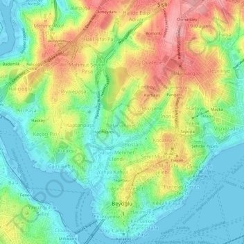
Name: Beyoğlu topographic map, elevation, terrain.

Location: Beyoğlu, Istanbul, Marmara Region, Turkey (41.02108 28.93901 41.06443 28.99578)

Average elevation: 48 m

Minimum elevation: -4 m

Maximum elevation: 126 m

Other topographic maps

Click on a map to view its topography, its elevation and its terrain.

Istanbul

Turkey > Istanbul > Fatih

Average elevation: 57 m

Moda Parkı

Turkey > Istanbul > Kadıköy

Average elevation: 4 m

Bebek Parkı

Turkey > Istanbul > Beşiktaş

Average elevation: 63 m

Binkılıç

Turkey > Istanbul > Çatalca

Average elevation: 206 m

Istanbul

Turkey > Istanbul > Fatih

Average elevation: 57 m

Binkılıç

Turkey > Istanbul > Çatalca

Average elevation: 206 m

Almaata Çocuk Parkı

Turkey > Istanbul > Avcılar

Average elevation: 23 m

Binkılıç

Turkey > Istanbul > Çatalca

Average elevation: 206 m

Heybeliada

Turkey > Istanbul > Prince Islands

Average elevation: 11 m

Tenzile Erdoğan Parkı 1

Turkey > Istanbul > Pendik

Average elevation: 106 m

Gear up for your next adventure:

🧭GPS Handheld Device - Reliable GPS navigation for outdoor adventures
🥾Trail Hiking Boots - Supportive boots for rough trails
🔋Solar Power Bank - Keep your GPS and devices charged during long outdoor trips
🛶Kayak Accessories - Essential gear for safe and fun kayaking adventures
🥘Camping Cookware Set - Compact nesting pots and pans for trail cooking

As an Amazon Associate, this site earns from qualifying purchases at no extra cost to you.