Geolocate

Edgewater topographic map

Click on the map to display elevation.

About this map

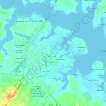
Name: Edgewater topographic map, elevation, terrain.

Location: Edgewater, Anne Arundel County, Maryland, United States (38.91806 -76.58221 38.95361 -76.52772)

Average elevation: 7 m

Minimum elevation: -3 m

Maximum elevation: 47 m

Other topographic maps

Click on a map to view its topography, its elevation and its terrain.

Gear up for your next adventure:

🥽Outdoor Goggles - Protective eyewear for outdoor activities
🚲Heavy Duty Bike Lock - Secure your bike at the trailhead or during stops
🧼Travel Hand Sanitizer - Keep hands clean when water is scarce
🧦Thermal Socks - Warm socks for winter hiking or camping
🛶Waterproof Dry Bags - Keep electronics and clothes dry during river crossings

As an Amazon Associate, this site earns from qualifying purchases at no extra cost to you.