
Make a donation
Gear up for your next adventure:
As an Amazon Associate, this site earns from qualifying purchases at no extra cost to you.
Archena topographic map
Click on the map to display elevation.
Make a donation
Gear up for your next adventure:
As an Amazon Associate, this site earns from qualifying purchases at no extra cost to you.
Archena
Die Kleinstadt Archena liegt am Río Segura gut 25 km (Fahrtstrecke) nordwestlich der Stadt Murcia in einer Höhe von ca. 110 m ü. d. M. Das Klima im Winter ist gemäßigt, im Sommer dagegen warm bis heiß; die geringen Niederschlagsmengen (ca. 300 mm/Jahr) fallen – mit Ausnahme der nahezu regenlosen Sommermonate – verteilt übers ganze Jahr.
Make a donation
Gear up for your next adventure:
As an Amazon Associate, this site earns from qualifying purchases at no extra cost to you.
About this map
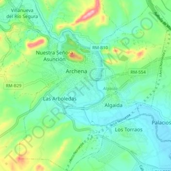
Name: Archena topographic map, elevation, terrain.
Average elevation: 131 m
Minimum elevation: 80 m
Maximum elevation: 271 m
Make a donation
Gear up for your next adventure:
As an Amazon Associate, this site earns from qualifying purchases at no extra cost to you.